
Make a donation
Gear up for your next adventure:
As an Amazon Associate, this site earns from qualifying purchases at no extra cost to you.
Nauders - San Benedetto topographic map
Click on the map to display elevation.
Make a donation
Gear up for your next adventure:
As an Amazon Associate, this site earns from qualifying purchases at no extra cost to you.
About this map
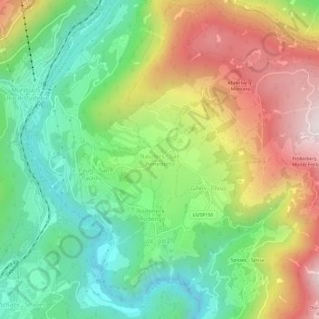
Name: Nauders - San Benedetto topographic map, elevation, terrain.
Average elevation: 996 m
Minimum elevation: 616 m
Maximum elevation: 1,555 m
Make a donation
Gear up for your next adventure:
As an Amazon Associate, this site earns from qualifying purchases at no extra cost to you.
Other topographic maps
Click on a map to view its topography, its elevation and its terrain.
Marèo - Enneberg - Marebbe
Italy > Trentino-Alto Adige/Südtirol > South Tyrol
Average elevation: 1,879 m
Jenesien - San Genesio Atesino
Italy > Trentino-Alto Adige/Südtirol > South Tyrol
Average elevation: 1,136 m
Make a donation
Gear up for your next adventure:
As an Amazon Associate, this site earns from qualifying purchases at no extra cost to you.
Pragser Wildsee - Lago di Braies
Italy > Trentino-Alto Adige/Südtirol > South Tyrol > Prags - Braies
Average elevation: 1,744 m
Sankt Pankraz - San Pancrazio
Italy > Trentino-Alto Adige/Südtirol > South Tyrol
Average elevation: 1,385 m
Make a donation
Gear up for your next adventure:
As an Amazon Associate, this site earns from qualifying purchases at no extra cost to you.
Taufers im Münstertal - Tubre
Italy > Trentino-Alto Adige/Südtirol > South Tyrol > Taufers im Münstertal - Tubre
Average elevation: 1,919 m