
Orcival topographic map
Click on the map to display elevation.
About this map
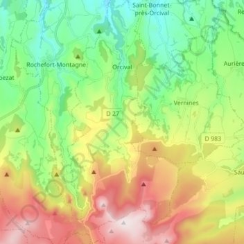
Name: Orcival topographic map, elevation, terrain.
Average elevation: 1,062 m
Minimum elevation: 777 m
Maximum elevation: 1,525 m
Other topographic maps
Click on a map to view its topography, its elevation and its terrain.
Nadaillat
France > Auvergne-Rhône-Alpes > Puy-de-Dôme > Saint-Genès-Champanelle
Average elevation: 822 m
Pôle Aqualudique
France > Auvergne-Rhône-Alpes > Puy-de-Dôme > La Bourboule > Les Vernières
Average elevation: 996 m