
Make a donation
Gear up for your next adventure:
As an Amazon Associate, this site earns from qualifying purchases at no extra cost to you.
Bad Wimpfen topographic map
Click on the map to display elevation.
Make a donation
Gear up for your next adventure:
As an Amazon Associate, this site earns from qualifying purchases at no extra cost to you.
About this map
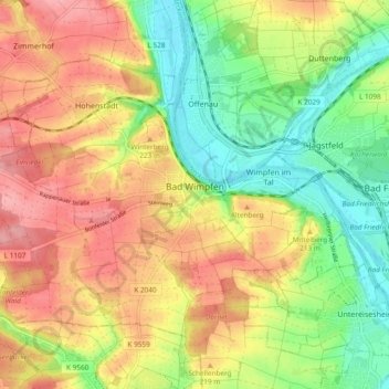
Name: Bad Wimpfen topographic map, elevation, terrain.
Average elevation: 199 m
Minimum elevation: 143 m
Maximum elevation: 256 m
Make a donation
Gear up for your next adventure:
As an Amazon Associate, this site earns from qualifying purchases at no extra cost to you.
Other topographic maps
Click on a map to view its topography, its elevation and its terrain.
Farnersberg
Germany > Baden-Württemberg > Landkreis Heilbronn > Beilstein > Farnersberg
Average elevation: 368 m
Make a donation
Gear up for your next adventure:
As an Amazon Associate, this site earns from qualifying purchases at no extra cost to you.
Lampoldshausen
Germany > Baden-Württemberg > Landkreis Heilbronn > Hardthausen am Kocher > Lampoldshausen
Average elevation: 263 m