Geolocate

Avín topographic map

Click on the map to display elevation.

About this map

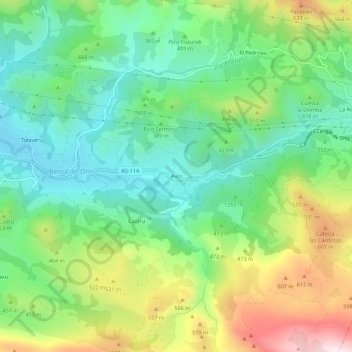
Name: Avín topographic map, elevation, terrain.

Location: Avín, Benia de Onís, Onís, Asturias, 33556, Spain (43.31445 -4.97183 43.35445 -4.93183)

Average elevation: 393 m

Minimum elevation: 185 m

Maximum elevation: 786 m

Gear up for your next adventure:

🧦Hiking Liner Socks - Thin base layer to prevent friction and blisters
🥽Outdoor Goggles - Protective eyewear for outdoor activities
🧊Insulated Water Bottle - Keeps drinks cold in summer and prevents freezing in winter
👟Leg Gaiters - Keep debris, mud, and snow out of your boots
🪜Heavy Duty Carabiners - Multi-use clips for securing gear to your backpack

As an Amazon Associate, this site earns from qualifying purchases at no extra cost to you.