
Cerro San Cristóbal topographic map
Interactive map
Click on the map to display elevation.
Cerro San Cristóbal
The summit of Cerro San Cristóbal can be reached by foot (about a 45-minute walk, involving a 300m change in elevation), by car via the road joining the Santiago Metropolitan Park, by the Funicular de Santiago (the base of which sits next to the Zoo at the North end of Pio Nono in Barrio Bellavista), or by a Teleferico (cable car located northeast at the Oasis station).
About this map
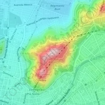
Name: Cerro San Cristóbal topographic map, elevation, terrain.
Average elevation: 615 m
Minimum elevation: 525 m
Maximum elevation: 877 m
Other topographic maps
Click on a map to view its topography, its elevation and its terrain.
Santiago
Chile > Santiago Metropolitan Region > Provincia de Santiago
The city lies in the center of the Santiago Basin, a large bowl-shaped valley consisting of broad and fertile lands surrounded by mountains. The city has a varying elevation, gradually increasing from 400 m (1,312 ft) in the western areas to more than 700 m (2,297 ft) in the eastern areas. Santiago's…
Average elevation: 553 m
Lo Barnechea
Chile > Santiago Metropolitan Region > Provincia de Santiago
Its pre-Hispanic inhabitants were called huaicoches (in Mapudungún: waykoche 'people who live in a landslide zone') because of the huaicos or huaycos of the region (in Quechua: wayqu 'stream'). Also called lloclla (in Quechua: lluqlla 'alluvium'), these are violent alluvial floods in which a large amount of…
Average elevation: 2,384 m
Santiago
Chile > Santiago Metropolitan Region > Provincia de Santiago
The city lies in the center of the Santiago Basin, a large bowl-shaped valley consisting of broad and fertile lands surrounded by mountains. The city has a varying elevation, gradually increasing from 400 m (1,312 ft) in the western areas to more than 700 m (2,297 ft) in the eastern areas. Santiago's…
Average elevation: 553 m
Parque Quinta Normal
Chile > Santiago Metropolitan Region > Provincia de Santiago > Santiago
Average elevation: 526 m
Conchalí
Chile > Santiago Metropolitan Region > Provincia de Santiago > Conchalí
Average elevation: 510 m
Quilicura
Chile > Santiago Metropolitan Region > Provincia de Santiago > Quilicura
Average elevation: 501 m
Recoleta
Chile > Santiago Metropolitan Region > Provincia de Santiago > Recoleta
Average elevation: 574 m
La Pintana
Chile > Santiago Metropolitan Region > Provincia de Santiago > La Pintana
Average elevation: 625 m
Pedro Aguirre Cerda
Chile > Santiago Metropolitan Region > Provincia de Santiago
Average elevation: 529 m