Geolocate

Bennewitz topographic map

Click on the map to display elevation.

About this map

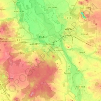
Name: Bennewitz topographic map, elevation, terrain.

Location: Bennewitz, Landkreis Leipzig, Saxony, 04828, Germany (51.29522 12.63941 51.40127 12.75877)

Average elevation: 134 m

Minimum elevation: 82 m

Maximum elevation: 179 m

Other topographic maps

Click on a map to view its topography, its elevation and its terrain.

Oellschütz

Germany > Saxony > Landkreis Leipzig > Groitzsch > Hohendorf

Average elevation: 138 m

Gear up for your next adventure:

🍽️Titanium Camping Spork - Ultralight and indestructible eating utensil
🔋Solar Power Bank - Keep your GPS and devices charged during long outdoor trips
🦟Insect Repellent - Keep mosquitoes and black flies away in wooded areas
🧭GPS Outdoor Watch - Smart watch for navigation and fitness tracking in nature
👟Leg Gaiters - Keep debris, mud, and snow out of your boots

As an Amazon Associate, this site earns from qualifying purchases at no extra cost to you.