
Thank you for supporting this site ❤️
Make a donation
Make a donation
Gear up for your next adventure:
As an Amazon Associate, this site earns from qualifying purchases at no extra cost to you.
Nadiad topographic map
Click on the map to display elevation.
Thank you for supporting this site ❤️
Make a donation
Make a donation
Gear up for your next adventure:
As an Amazon Associate, this site earns from qualifying purchases at no extra cost to you.
About this map
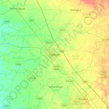
Name: Nadiad topographic map, elevation, terrain.
Location: Nadiad, Nadlad City Taluka, Kheda, Gujarat, 387001, India (22.52955 72.71136 22.84955 73.03136)
Average elevation: 38 m
Minimum elevation: 23 m
Maximum elevation: 57 m
Thank you for supporting this site ❤️
Make a donation
Make a donation
Gear up for your next adventure:
As an Amazon Associate, this site earns from qualifying purchases at no extra cost to you.