Geolocate

Luray topographic map

Click on the map to display elevation.

About this map
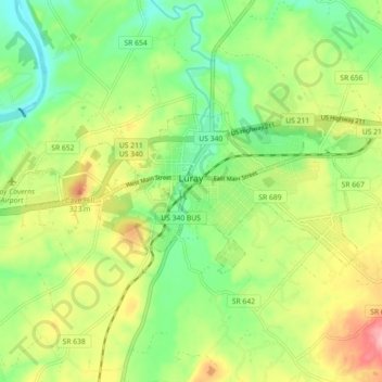
Name: Luray topographic map, elevation, terrain.

Location: Luray, Page County, Virginia, 22835, United States (38.64795 -78.50739 38.67804 -78.41778)

Average elevation: 267 m

Minimum elevation: 210 m

Maximum elevation: 350 m

Other topographic maps

Click on a map to view its topography, its elevation and its terrain.

Rileyville

United States > Virginia > Page County

Average elevation: 244 m

Luray Caverns

United States > Virginia > Page County > Luray

Average elevation: 277 m

Third Mountain

United States > Virginia > Page County

Average elevation: 704 m

Newport

United States > Virginia > Page County

Average elevation: 328 m

Shenandoah Forest

United States > Virginia > Page County

Average elevation: 371 m

Ida

United States > Virginia > Page County

Average elevation: 462 m

Gear up for your next adventure:

💧Filtered Water Bottle - Safe drinking water on the go
🥾Waterproof Hiking Boots - Boots keeping your feet dry in wet conditions
🔦LED Flashlight - Powerful and long-lasting flashlight for camping and emergencies
🧥Insulated Jacket - Keep warm in cold outdoor conditions
⛺Lightweight Backpacking Tent - Compact tent for efficient hiking trips

As an Amazon Associate, this site earns from qualifying purchases at no extra cost to you.