Geolocate

Caersws topographic map

Click on the map to display elevation.

About this map

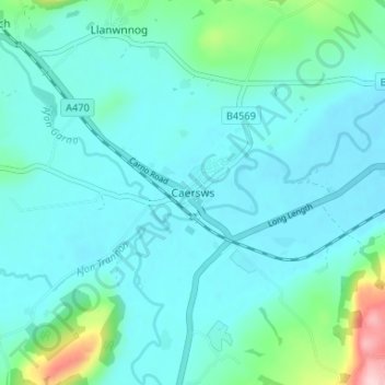
Name: Caersws topographic map, elevation, terrain.

Location: Caersws, Powys, Wales, SY17 5DS, United Kingdom (52.49669 -3.44878 52.53669 -3.40878)

Average elevation: 145 m

Minimum elevation: 115 m

Maximum elevation: 320 m

Other topographic maps

Click on a map to view its topography, its elevation and its terrain.

Mochdre

United Kingdom > Wales > Powys

Average elevation: 291 m

Gear up for your next adventure:

🥾Hiking Shoes - Durable and comfortable shoes for trail hiking
🧭GPS Outdoor Watch - Smart watch for navigation and fitness tracking in nature
🥾Light Hiking Boots - Lightweight and comfortable boots for day hikes
🔋Solar Power Bank - Keep your GPS and devices charged during long outdoor trips
🪑Insulated Seat Pad - Protect your seat from cold rocks and wet logs

As an Amazon Associate, this site earns from qualifying purchases at no extra cost to you.