
Make a donation
Gear up for your next adventure:
As an Amazon Associate, this site earns from qualifying purchases at no extra cost to you.
Benito Juárez topographic map
Click on the map to display elevation.
Make a donation
Gear up for your next adventure:
As an Amazon Associate, this site earns from qualifying purchases at no extra cost to you.
Benito Juárez
In response to the French invasion and the elevation of Maximilian as Emperor of Mexico, Juárez sent General Plácido Vega y Daza to California to gather Mexican American sympathy for republican Mexico. Maximilian offered Juárez amnesty and later the post of prime minister, but Juárez refused to accept a government "imposed by foreigners," or a monarchy. The US government was sympathetic to Juárez, refusing to recognize Maximilian and opposing the French invasion as a violation of the Monroe Doctrine. Most of its attention was taken up by the American Civil War.
Make a donation
Gear up for your next adventure:
As an Amazon Associate, this site earns from qualifying purchases at no extra cost to you.
About this map
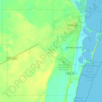
Name: Benito Juárez topographic map, elevation, terrain.
Location: Benito Juárez, Quintana Roo, Mexico (20.72845 -87.32335 21.23177 -86.74054)
Average elevation: 7 m
Minimum elevation: -4 m
Maximum elevation: 21 m
Make a donation
Gear up for your next adventure:
As an Amazon Associate, this site earns from qualifying purchases at no extra cost to you.