Geolocate
👉 Easily get elevation data in JSON, GeoTIFF and KML formats using Elevation API
Thank you for supporting this site ❤️
Make a donation

West topographic map

Click on the map to display elevation.

About this map

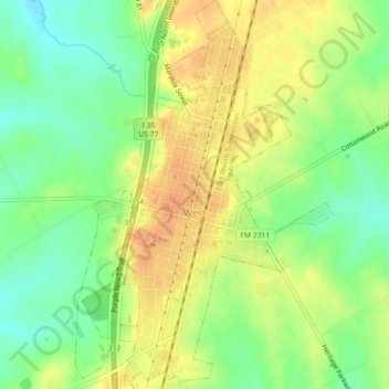
Name: West topographic map, elevation, terrain.

Location: West, McLennan County, Texas, United States (31.78610 -97.10720 31.82434 -97.07731)

Average elevation: 186 m

Minimum elevation: 165 m

Maximum elevation: 205 m

Other topographic maps

Click on a map to view its topography, its elevation and its terrain.

Cameron Park

United States > Texas > McLennan County > Waco

Average elevation: 137 m

Elm Mott

United States > Texas > McLennan County

Average elevation: 156 m

Hewitt

United States > Texas > McLennan County > Hewitt > Hewitt

Average elevation: 189 m

Bruceville-Eddy

United States > Texas > McLennan County

Average elevation: 198 m

Waco

United States > Texas > McLennan County > Waco

Average elevation: 150 m

Gear up for your next adventure:

🧥Thermal Fleece Jacket - Versatile insulation for changing mountain temperatures
🔪Outdoor Multitool - Versatile tool for repairs and food prep in the wild
🧢Beanie Hat - Keep your head warm in cold weather
🥾Approach Boots - Comfortable boots for hiking and climbing approaches
🥾Light Hiking Boots - Lightweight and comfortable boots for day hikes

As an Amazon Associate, this site earns from qualifying purchases at no extra cost to you.