
Thank you for supporting this site ❤️
Make a donation
Make a donation
Gear up for your next adventure:
As an Amazon Associate, this site earns from qualifying purchases at no extra cost to you.
Tunbridge topographic map
Click on the map to display elevation.
Thank you for supporting this site ❤️
Make a donation
Make a donation
Gear up for your next adventure:
As an Amazon Associate, this site earns from qualifying purchases at no extra cost to you.
About this map
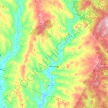
Name: Tunbridge topographic map, elevation, terrain.
Location: Tunbridge, Orange County, Vermont, 05077, United States (43.83809 -72.57360 43.96619 -72.39420)
Average elevation: 361 m
Minimum elevation: 148 m
Maximum elevation: 655 m
Thank you for supporting this site ❤️
Make a donation
Make a donation
Gear up for your next adventure:
As an Amazon Associate, this site earns from qualifying purchases at no extra cost to you.
Other topographic maps
Click on a map to view its topography, its elevation and its terrain.
Topsham Four Corners
United States > Vermont > Orange County > Topsham > Topsham
Average elevation: 346 m