
Make a donation
Gear up for your next adventure:
As an Amazon Associate, this site earns from qualifying purchases at no extra cost to you.
Ossipee topographic map
Click on the map to display elevation.
Make a donation
Gear up for your next adventure:
As an Amazon Associate, this site earns from qualifying purchases at no extra cost to you.
Ossipee
The two primary settlements in town are Center Ossipee, located near the southern junction of routes 16 and 25, and Ossipee Corner (shown as "Ossipee" on topographic maps), located 5 miles (8 km) south of Center Ossipee at the junction of routes 28 and 171 and close to Route 16. Other villages include West Ossipee, at the northern junction of routes 16 and 25 near the border with Tamworth; Moultonville, directly west of Center Ossipee; and Water Village, along Route 171 near the border with Tuftonboro.
Make a donation
Gear up for your next adventure:
As an Amazon Associate, this site earns from qualifying purchases at no extra cost to you.
About this map
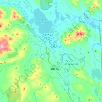
Name: Ossipee topographic map, elevation, terrain.
Location: Ossipee, Carroll County, New Hampshire, United States (43.63642 -71.27994 43.83284 -71.01360)
Average elevation: 217 m
Minimum elevation: 114 m
Maximum elevation: 715 m
Make a donation
Gear up for your next adventure:
As an Amazon Associate, this site earns from qualifying purchases at no extra cost to you.
Other topographic maps
Click on a map to view its topography, its elevation and its terrain.