Geolocate

Malandag topographic map

Click on the map to display elevation.

About this map

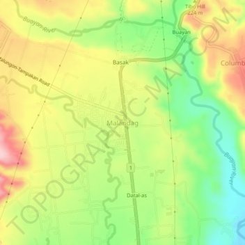
Name: Malandag topographic map, elevation, terrain.

Location: Malandag, Sarangani, Soccsksargen, 9503, Philippines (6.28840 125.23225 6.32840 125.27225)

Average elevation: 183 m

Minimum elevation: 81 m

Maximum elevation: 293 m

Gear up for your next adventure:

🔋Solar Power Bank - Keep your GPS and devices charged during long outdoor trips
🧴Sunscreen SPF - Broad-spectrum sunscreen for outdoor activities
🧢Outdoor Cap - Protective cap for sun and rain during hikes
🧥Softshell Jacket - Windproof and breathable jacket for hiking
🧴First Aid Kit - Essential first aid supplies for outdoor emergencies

As an Amazon Associate, this site earns from qualifying purchases at no extra cost to you.