
Make a donation
Gear up for your next adventure:
As an Amazon Associate, this site earns from qualifying purchases at no extra cost to you.
Armenia topographic map
Click on the map to display elevation.
Make a donation
Gear up for your next adventure:
As an Amazon Associate, this site earns from qualifying purchases at no extra cost to you.
Armenia
Armenia has a territorial area of 29,743 square kilometres (11,484 sq mi). The terrain is mostly mountainous, with fast flowing rivers, and few forests. The land rises to 4,090 metres (13,419 feet) above sea level at Mount Aragats, and no point is below 390 metres (1,280 ft) above sea level. Average elevation of the country area is 10th highest in the world and it has 85.9% mountain area, more than Switzerland or Nepal.
Make a donation
Gear up for your next adventure:
As an Amazon Associate, this site earns from qualifying purchases at no extra cost to you.
About this map
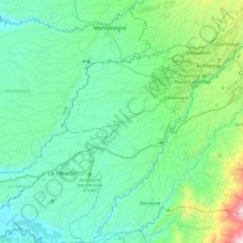
Name: Armenia topographic map, elevation, terrain.
Location: Armenia, Capital, Quindío, Colombia (4.39574 -75.78940 4.58959 -75.63250)
Average elevation: 1,709 m
Minimum elevation: 1,078 m
Maximum elevation: 3,715 m
Make a donation
Gear up for your next adventure:
As an Amazon Associate, this site earns from qualifying purchases at no extra cost to you.