Geolocate

Pegnitz topographic map

Click on the map to display elevation.

About this map

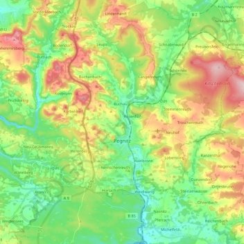
Name: Pegnitz topographic map, elevation, terrain.

Location: Pegnitz, Landkreis Bayreuth, Bavaria, 91257, Germany (49.69628 11.42391 49.83802 11.63376)

Average elevation: 485 m

Minimum elevation: 392 m

Maximum elevation: 637 m

Gear up for your next adventure:

💡Solar Camping Lamp - Eco-friendly lighting for campsites
🧤Thermal Hiking Gloves - Grip-enhanced gloves for cold-weather altitude trekking
🧦Thermal Socks - Warm socks for winter hiking or camping
💧Collapsible Water Bottle - Space-saving water bottle for outdoor activities
🥾Durable Hiking Shoes - Long-lasting shoes for frequent hiking

As an Amazon Associate, this site earns from qualifying purchases at no extra cost to you.