
Thank you for supporting this site ❤️
Make a donation
Make a donation
Gear up for your next adventure:
As an Amazon Associate, this site earns from qualifying purchases at no extra cost to you.
Westfield topographic map
Click on the map to display elevation.
Thank you for supporting this site ❤️
Make a donation
Make a donation
Gear up for your next adventure:
As an Amazon Associate, this site earns from qualifying purchases at no extra cost to you.
About this map
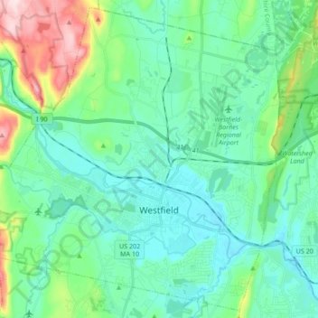
Name: Westfield topographic map, elevation, terrain.
Location: Westfield, Hampden County, Massachusetts, United States (42.08080 -72.85389 42.20047 -72.68489)
Average elevation: 100 m
Minimum elevation: 30 m
Maximum elevation: 359 m
Thank you for supporting this site ❤️
Make a donation
Make a donation
Gear up for your next adventure:
As an Amazon Associate, this site earns from qualifying purchases at no extra cost to you.
Other topographic maps
Click on a map to view its topography, its elevation and its terrain.
South End
United States > Massachusetts > Hampden County > Springfield > South End
Average elevation: 37 m