
Make a donation
Gear up for your next adventure:
As an Amazon Associate, this site earns from qualifying purchases at no extra cost to you.
Yarmouth topographic map
Click on the map to display elevation.
Make a donation
Gear up for your next adventure:
As an Amazon Associate, this site earns from qualifying purchases at no extra cost to you.
About this map
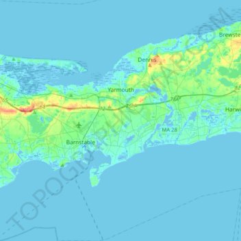
Name: Yarmouth topographic map, elevation, terrain.
Location: Yarmouth, Barnstable County, Massachusetts, United States (41.55575 -70.29487 41.79395 -70.15925)
Average elevation: 5 m
Minimum elevation: -6 m
Maximum elevation: 58 m
Make a donation
Gear up for your next adventure:
As an Amazon Associate, this site earns from qualifying purchases at no extra cost to you.
Other topographic maps
Click on a map to view its topography, its elevation and its terrain.
South Dennis
United States > Massachusetts > Barnstable County > Dennis > South Dennis
Average elevation: 9 m
Mashpee Neck
United States > Massachusetts > Barnstable County > Mashpee > Mashpee Neck
Average elevation: 10 m
CR #10
United States > Massachusetts > Barnstable County > Falmouth > Saconesset Hills
Average elevation: 14 m