
Make a donation
Gear up for your next adventure:
As an Amazon Associate, this site earns from qualifying purchases at no extra cost to you.
Ždiar topographic map
Click on the map to display elevation.
Make a donation
Gear up for your next adventure:
As an Amazon Associate, this site earns from qualifying purchases at no extra cost to you.
Ždiar
The municipality lies at an elevation of 896 meters at the base of the High Tatras and covers an area of 27.323 km². It has a population of about 1,340 people.
Make a donation
Gear up for your next adventure:
As an Amazon Associate, this site earns from qualifying purchases at no extra cost to you.
About this map
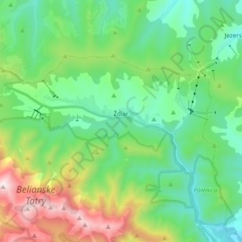
Name: Ždiar topographic map, elevation, terrain.
Location: Ždiar, District of Poprad, Region of Prešov, 059 55, Slovakia (49.24463 20.18246 49.29156 20.31501)
Average elevation: 1,105 m
Minimum elevation: 722 m
Maximum elevation: 2,091 m
Make a donation
Gear up for your next adventure:
As an Amazon Associate, this site earns from qualifying purchases at no extra cost to you.