Geolocate

Paignton topographic map

Click on the map to display elevation.

About this map

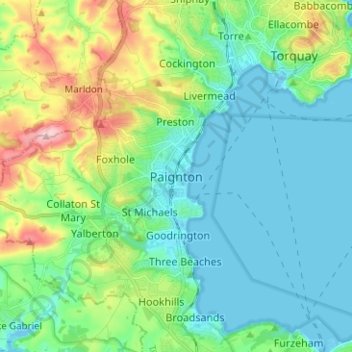
Name: Paignton topographic map, elevation, terrain.

Location: Paignton, Torbay, England, TQ3 2BL, United Kingdom (50.39770 -3.60327 50.47770 -3.52327)

Average elevation: 49 m

Minimum elevation: -4 m

Maximum elevation: 194 m

Gear up for your next adventure:

🥘Camping Cookware Set - Compact nesting pots and pans for trail cooking
🥾Lightweight Hiking Shoes - Comfortable shoes for day hikes
🔋Solar Power Bank - Keep your GPS and devices charged during long outdoor trips
🧰Multitool Knife - Compact and versatile tool for outdoor use
🧴Sunscreen SPF - Broad-spectrum sunscreen for outdoor activities

As an Amazon Associate, this site earns from qualifying purchases at no extra cost to you.