Geolocate

Telluride topographic map

Click on the map to display elevation.

Telluride

Telluride has an elevation of 8,750 feet (2,670 m) in an isolated spot in Southwest Colorado. From the west, Colorado Route 145 is the most common way into Telluride; two other passes enter the town, Imogene Pass and Black Bear Pass.

Wikipedia (CC-BY-SA 3.0)

About this map

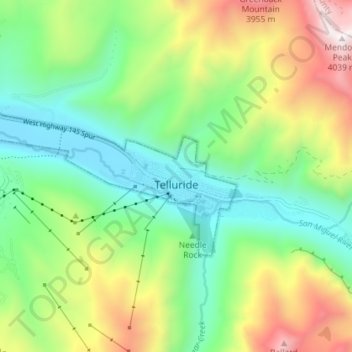
Name: Telluride topographic map, elevation, terrain.

Location: Telluride, San Miguel County, Colorado, 81435, United States (37.92600 -107.87171 37.95161 -107.79994)

Average elevation: 3,125 m

Minimum elevation: 2,647 m

Maximum elevation: 4,023 m

Gear up for your next adventure:

🧴First Aid Kit - Essential first aid supplies for outdoor emergencies
Family Camping Tent - Spacious tent suitable for family camping trips
🥫Freeze-Dried Meals - Lightweight, high-calorie nutrition for multi-day treks
🥾Waterproof Trail Shoes - Shoes designed to handle wet terrain
🥾Hiking Shorts - Breathable shorts suitable for summer hikes

As an Amazon Associate, this site earns from qualifying purchases at no extra cost to you.