
Make a donation
Gear up for your next adventure:
As an Amazon Associate, this site earns from qualifying purchases at no extra cost to you.
Punta Cana topographic map
Click on the map to display elevation.
Make a donation
Gear up for your next adventure:
As an Amazon Associate, this site earns from qualifying purchases at no extra cost to you.
Punta Cana
Punta Cana, located at the easternmost tip of the Dominican Republic, is characterized by its predominantly flat terrain, with elevations averaging around 30 feet (9 meters) above sea level. This low-lying landscape contributes to the area's expansive white-sand beaches and extensive coconut palm groves. The region's flatness facilitates the formation of natural marine pools along the coastline, offering safe and tranquil bathing spots for visitors. Inland, the terrain remains relatively level, transitioning into fertile plains that support various agricultural activities. This combination of flat coastal areas and productive inland plains defines Punta Cana's distinctive topography.
Make a donation
Gear up for your next adventure:
As an Amazon Associate, this site earns from qualifying purchases at no extra cost to you.
About this map
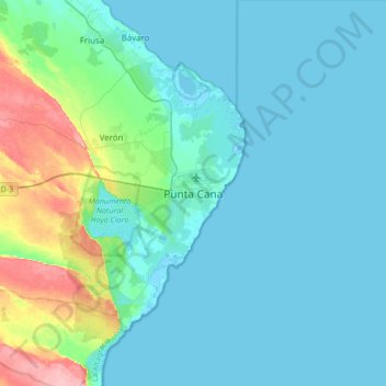
Name: Punta Cana topographic map, elevation, terrain.
Location: Punta Cana, Higüey, La Altagracia, 23300, Dominican Republic (18.39655 -68.52916 18.71655 -68.20916)
Average elevation: 18 m
Minimum elevation: -3 m
Maximum elevation: 112 m
Make a donation
Gear up for your next adventure:
As an Amazon Associate, this site earns from qualifying purchases at no extra cost to you.
Other topographic maps
Click on a map to view its topography, its elevation and its terrain.