Geolocate

Ituiutaba topographic map

Click on the map to display elevation.

Ituiutaba

Ituiutaba (Brazilian Portuguese: /itujuˈtabɐ/) is a municipality in the western part of Minas Gerais state, Brazil. Elevated to city status in 1901, its population in 2020 was 105,255 and a total area in the municipality of 2,694 km2. The elevation of the seat of the municipality is 544 m.

About this map

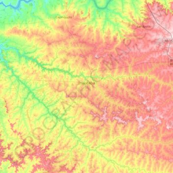
Name: Ituiutaba topographic map, elevation, terrain.

Location: Ituiutaba, Região Geográfica Imediata de Ituiutaba, Região Geográfica Intermediária de Uberlândia, Minas Gerais, Southeast Region, Brazil (-19.36150 -49.87200 -18.60875 -49.18142)

Average elevation: 581 m

Minimum elevation: 398 m

Maximum elevation: 795 m

Gear up for your next adventure:

🥾Mountain Trail Shoes - High-traction shoes for mountain trails
🧴Insect Repellent - Protect yourself from bugs during outdoor adventures
🪑Ultralight Camping Stool - Compact seating for rest stops during long hikes
👟Trail Running Shoes - Agile footwear for fast-paced topographic exploration
🔭Compact Monocular - One-handed bird watching and trail spotting

As an Amazon Associate, this site earns from qualifying purchases at no extra cost to you.