Geolocate

Dosquebradas topographic map

Click on the map to display elevation.

About this map

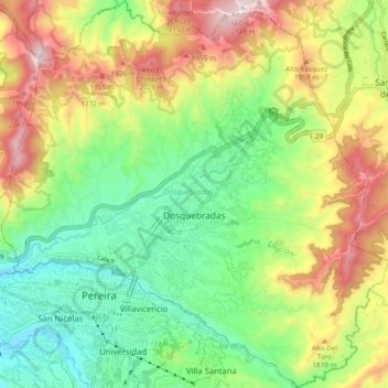
Name: Dosquebradas topographic map, elevation, terrain.

Location: Dosquebradas, AMCO, Area Metropolitana Centro Occidente, Risaralda, RAP Eje Cafetero, Colombia (4.79182 -75.71864 4.88641 -75.62348)

Average elevation: 1,628 m

Minimum elevation: 1,283 m

Maximum elevation: 2,161 m

Other topographic maps

Click on a map to view its topography, its elevation and its terrain.

Alto Cerritos

Colombia > Risaralda

Average elevation: 1,169 m

Beltran

Colombia > Risaralda > Marsella

Average elevation: 1,078 m

Pereira

Colombia > Risaralda > Pereira > Pereira

Average elevation: 1,564 m

Gear up for your next adventure:

🪑Insulated Seat Pad - Protect your seat from cold rocks and wet logs
🦌Outdoor Trail Camera - Monitor wildlife activity near your favorite spots
🧦Hiking Socks - Moisture-wicking and comfortable socks for long hikes
🧥Waterproof Jacket - Lightweight rain jackets for hiking and outdoor activities
🧥Insulated Jacket - Keep warm in cold outdoor conditions

As an Amazon Associate, this site earns from qualifying purchases at no extra cost to you.