
Thank you for supporting this site ❤️
Make a donation
Make a donation
Gear up for your next adventure:
As an Amazon Associate, this site earns from qualifying purchases at no extra cost to you.
Latacunga topographic map
Click on the map to display elevation.
Thank you for supporting this site ❤️
Make a donation
Make a donation
Gear up for your next adventure:
As an Amazon Associate, this site earns from qualifying purchases at no extra cost to you.
About this map
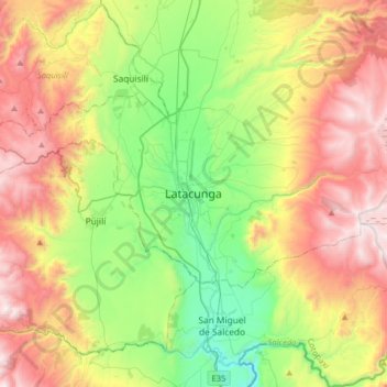
Name: Latacunga topographic map, elevation, terrain.
Location: Latacunga, Cotopaxi, 0501, Ecuador (-1.09403 -78.77458 -0.77403 -78.45458)
Average elevation: 3,213 m
Minimum elevation: 2,526 m
Maximum elevation: 4,165 m
Thank you for supporting this site ❤️
Make a donation
Make a donation
Gear up for your next adventure:
As an Amazon Associate, this site earns from qualifying purchases at no extra cost to you.