
Make a donation
Gear up for your next adventure:
As an Amazon Associate, this site earns from qualifying purchases at no extra cost to you.
São Joaquim topographic map
Click on the map to display elevation.
Make a donation
Gear up for your next adventure:
As an Amazon Associate, this site earns from qualifying purchases at no extra cost to you.
São Joaquim
Due to its altitude above 3280 ft (1000 m) and a few degrees below the tropics, the city has an oceanic climate (Köppen climate classification: Cfb) modified for precipitation sufficiently moist in every month, more abundant throughout the year (usually more evenly distributed than in Campos do Jordão), with cool summers and low temperatures in winter, but not below freezing. The average annual temperature is 11.4 °C to 14.3 °C. The maximum average does not exceed 20 °C. At the same time, the minimum averages are above 7 °C. The annual precipitation is high, from 1450 mm to 1650 mm, and about 135 rainy days. Winter precipitation can occur at crucial times in the season, but tend not to be plentiful and cumulative, except on a few occasions. Together with Urupema, Urubici, Bom Jardim da Serra and São José dos Ausentes, São Joaquim is considered the coldest city in Brazil if the maximum average temperature and the number of cold hours are considered (loses to Urupema and Bom Jardim in absolute minimums). During the winter months, frost is common - every month is subject to the phenomenon, which is more common from May to September (in years of La Niña from April to October), although strong masses of polar air may enter as early as April. Outside winter, spring and fall may receive frosts due to the prevailing cold dry air. Frost can occur even in midsummer There are 40.8 days on average per year when freezing of soil and plants occurs between the years of 1980 and 2003 registered by the meteorological station in the place.
Make a donation
Gear up for your next adventure:
As an Amazon Associate, this site earns from qualifying purchases at no extra cost to you.
About this map
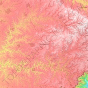
Name: São Joaquim topographic map, elevation, terrain.
Average elevation: 1,187 m
Minimum elevation: 133 m
Maximum elevation: 1,762 m
Make a donation
Gear up for your next adventure:
As an Amazon Associate, this site earns from qualifying purchases at no extra cost to you.