Geolocate

Tyler topographic map

Click on the map to display elevation.

About this map

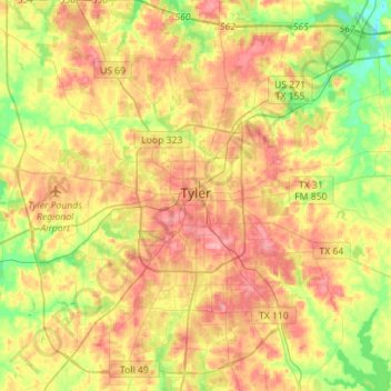
Name: Tyler topographic map, elevation, terrain.

Location: Tyler, Smith County, Texas, United States (32.23067 -95.41888 32.46788 -95.19329)

Average elevation: 147 m

Minimum elevation: 91 m

Maximum elevation: 203 m

Other topographic maps

Click on a map to view its topography, its elevation and its terrain.

Swan

United States > Texas > Smith County

Average elevation: 156 m

Thedford

United States > Texas > Smith County > Lindale

Average elevation: 155 m

Fun Forest Park

United States > Texas > Smith County > Tyler

Average elevation: 163 m

Owentown

United States > Texas > Smith County

Average elevation: 121 m

Whitehouse

United States > Texas > Smith County

Average elevation: 142 m

Tyler

United States > Texas > Smith County > Tyler

Average elevation: 142 m

Pine Springs

United States > Texas > Smith County > Tyler > Pine Springs

Average elevation: 155 m

Tyler

United States > Texas > Smith County

Average elevation: 147 m

Gear up for your next adventure:

🚑Survival Whistle - Signal for help across long distances in mountains
🦶Anti-Blister Balm - Prevents friction and hotspots during long ascents
🥾Waterproof Trail Shoes - Shoes designed to handle wet terrain
🎒Fully Waterproof Backpack - Total protection for photography gear and electronics
🪑Insulated Seat Pad - Protect your seat from cold rocks and wet logs

As an Amazon Associate, this site earns from qualifying purchases at no extra cost to you.