
Thank you for supporting this site ❤️
Make a donation
Make a donation
Gear up for your next adventure:
As an Amazon Associate, this site earns from qualifying purchases at no extra cost to you.
Algeciras topographic map
Click on the map to display elevation.
Thank you for supporting this site ❤️
Make a donation
Make a donation
Gear up for your next adventure:
As an Amazon Associate, this site earns from qualifying purchases at no extra cost to you.
About this map
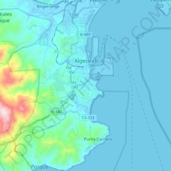
Name: Algeciras topographic map, elevation, terrain.
Location: Algeciras, Campo de Gibraltar, Cádiz, Andalusia, Spain (36.05020 -5.55110 36.17549 -5.42230)
Average elevation: 77 m
Minimum elevation: -7 m
Maximum elevation: 767 m
Thank you for supporting this site ❤️
Make a donation
Make a donation
Gear up for your next adventure:
As an Amazon Associate, this site earns from qualifying purchases at no extra cost to you.