Geolocate

Daun topographic map

Click on the map to display elevation.

About this map
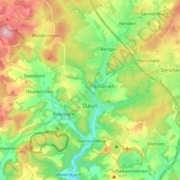
Name: Daun topographic map, elevation, terrain.

Location: Daun, Landkreis Vulkaneifel, Rhineland-Palatinate, 54550, Germany (50.16101 6.74411 50.24611 6.87554)

Average elevation: 485 m

Minimum elevation: 350 m

Maximum elevation: 696 m

Other topographic maps

Click on a map to view its topography, its elevation and its terrain.
Gear up for your next adventure:

☕Camping Coffee Maker - Brew fresh coffee anywhere on the topographic map
🪑Ultralight Camping Stool - Compact seating for rest stops during long hikes
🧢Sun Hat - Wide-brim hat for sun protection
🧴Bear Spray Holster - Quick-access carry for essential Canadian wilderness safety
🎒Fully Waterproof Backpack - Total protection for photography gear and electronics

As an Amazon Associate, this site earns from qualifying purchases at no extra cost to you.