Geolocate

Pell City topographic map

Click on the map to display elevation.

About this map

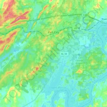
Name: Pell City topographic map, elevation, terrain.

Location: Pell City, St. Clair County, Alabama, United States (33.49304 -86.32695 33.62611 -86.19367)

Average elevation: 167 m

Minimum elevation: 137 m

Maximum elevation: 266 m

Other topographic maps

Click on a map to view its topography, its elevation and its terrain.

Harmon

United States > Alabama > St. Clair County > Pell City

Average elevation: 150 m

Ragland

United States > Alabama > St. Clair County

Average elevation: 188 m

Riverside

United States > Alabama > St. Clair County

Average elevation: 157 m

Walkerton

United States > Alabama > St. Clair County > Pell City

Average elevation: 176 m

Gear up for your next adventure:

🪜Heavy Duty Carabiners - Multi-use clips for securing gear to your backpack
🩹Moleskin Blister Pads - Direct protection for painful foot pressure points
🛁Quick-Dry Microfiber Towel - Space-saving towel that dries rapidly on the move
🦯Trekking Poles - Reduced impact on joints for steep topographic climbs
Camping Groundsheet - Protect your tent from moisture and dirt

As an Amazon Associate, this site earns from qualifying purchases at no extra cost to you.