
Thank you for supporting this site ❤️
Make a donation
Make a donation
Gear up for your next adventure:
As an Amazon Associate, this site earns from qualifying purchases at no extra cost to you.
Bayas topographic map
Click on the map to display elevation.
Thank you for supporting this site ❤️
Make a donation
Make a donation
Gear up for your next adventure:
As an Amazon Associate, this site earns from qualifying purchases at no extra cost to you.
About this map
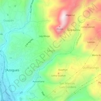
Name: Bayas topographic map, elevation, terrain.
Location: Bayas, Azogues, Cañar, 030102, Ecuador (-2.75030 -78.85169 -2.71030 -78.81169)
Average elevation: 2,712 m
Minimum elevation: 2,451 m
Maximum elevation: 3,139 m
Thank you for supporting this site ❤️
Make a donation
Make a donation
Gear up for your next adventure:
As an Amazon Associate, this site earns from qualifying purchases at no extra cost to you.