Geolocate

Chlumec topographic map

Click on the map to display elevation.

About this map
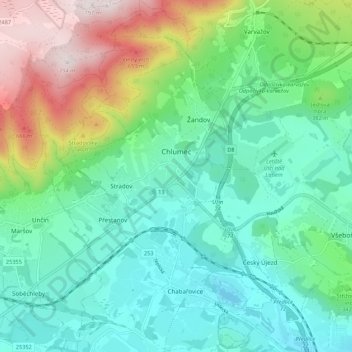
Name: Chlumec topographic map, elevation, terrain.

Location: Chlumec, okres Ústí nad Labem, Ústecký kraj, Northwest, 403 39, Czechia (50.66103 13.90406 50.72937 13.98495)

Average elevation: 325 m

Minimum elevation: 145 m

Maximum elevation: 790 m

Other topographic maps

Click on a map to view its topography, its elevation and its terrain.
Gear up for your next adventure:

🧴Outdoor Sunscreen - High SPF protection for high-altitude UV exposure
🧦Hiking Liner Socks - Thin base layer to prevent friction and blisters
🧦Crew Hiking Socks - Comfortable socks for long-distance hikes
🛁Quick-Dry Microfiber Towel - Space-saving towel that dries rapidly on the move
🥾Approach Boots - Comfortable boots for hiking and climbing approaches

As an Amazon Associate, this site earns from qualifying purchases at no extra cost to you.