
Thank you for supporting this site ❤️
Make a donation
Make a donation
Gear up for your next adventure:
As an Amazon Associate, this site earns from qualifying purchases at no extra cost to you.
Zillebeke topographic map
Click on the map to display elevation.
Thank you for supporting this site ❤️
Make a donation
Make a donation
Gear up for your next adventure:
As an Amazon Associate, this site earns from qualifying purchases at no extra cost to you.
About this map
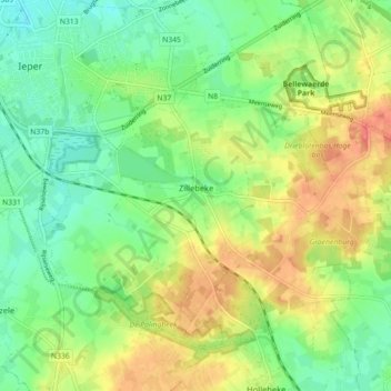
Name: Zillebeke topographic map, elevation, terrain.
Location: Zillebeke, Ypres, Ieper, West Flanders, Flanders, Belgium (50.81278 2.88746 50.85426 2.97656)
Average elevation: 36 m
Minimum elevation: 11 m
Maximum elevation: 70 m
Thank you for supporting this site ❤️
Make a donation
Make a donation
Gear up for your next adventure:
As an Amazon Associate, this site earns from qualifying purchases at no extra cost to you.