Geolocate

Gràcia topographic map

Click on the map to display elevation.

About this map

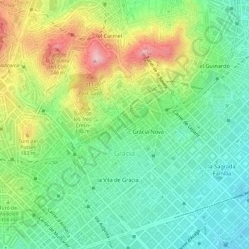
Name: Gràcia topographic map, elevation, terrain.

Location: Gràcia, Barcelona, Barcelonès, Barcelona, Catalonia, 08001, Spain (41.39556 2.12964 41.42489 2.17208)

Average elevation: 114 m

Minimum elevation: 24 m

Maximum elevation: 288 m

Other topographic maps

Click on a map to view its topography, its elevation and its terrain.

Mirador del Migdia

Spain > Catalonia > Barcelonès > Barcelona

Average elevation: 40 m

Gear up for your next adventure:

🧦Merino Wool Socks - Moisture-wicking comfort for long-distance hiking
🧥Waterproof Pants - Keep dry during rainy hiking conditions
💧Filtered Water Bottle - Safe drinking water on the go
🔪Outdoor Multitool - Versatile tool for repairs and food prep in the wild
🔋Solar Power Bank - Keep your GPS and devices charged during long outdoor trips

As an Amazon Associate, this site earns from qualifying purchases at no extra cost to you.