
Make a donation
Gear up for your next adventure:
As an Amazon Associate, this site earns from qualifying purchases at no extra cost to you.
Carmen topographic map
Click on the map to display elevation.
Make a donation
Gear up for your next adventure:
As an Amazon Associate, this site earns from qualifying purchases at no extra cost to you.
About this map
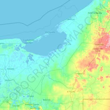
Name: Carmen topographic map, elevation, terrain.
Location: Carmen, Campeche, Mexico (17.87351 -92.46903 19.03233 -90.79543)
Average elevation: 20 m
Minimum elevation: -7 m
Maximum elevation: 174 m
Make a donation
Gear up for your next adventure:
As an Amazon Associate, this site earns from qualifying purchases at no extra cost to you.
Other topographic maps
Click on a map to view its topography, its elevation and its terrain.
Make a donation
Gear up for your next adventure:
As an Amazon Associate, this site earns from qualifying purchases at no extra cost to you.
Hecelchakán
Mexico > Campeche > Hecelchakán
It is at an altitude of 10 m above sea level.
Average elevation: 34 m