
Make a donation
Gear up for your next adventure:
As an Amazon Associate, this site earns from qualifying purchases at no extra cost to you.
Deißlingen topographic map
Click on the map to display elevation.
Make a donation
Gear up for your next adventure:
As an Amazon Associate, this site earns from qualifying purchases at no extra cost to you.
Deißlingen
The municipality (Gemeinde) of Deißlingen covers 32.15 square kilometers (12.41 sq mi) of the Rottweil district of Baden-Württemberg, which assigns Deißlingen to the metropolitan area of Villingen-Schwenningen, Tuttlingen, and Rottweil. Deißlingen is physically located in a transitional landscape between the muschelkalk-keuper plateaus of the Upper Gäu [de] to the north, the Swabian Jura to the east, and the Baar to the south. Elevation above sea level in the municipal area ranges from a high of 753 meters (2,470 ft) Normalnull (NN) at the border with Tuttlingen district to a low of 574 meters (1,883 ft) NN on the Neckar as it forms the border with Rottweil.
Make a donation
Gear up for your next adventure:
As an Amazon Associate, this site earns from qualifying purchases at no extra cost to you.
About this map
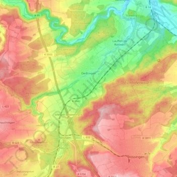
Name: Deißlingen topographic map, elevation, terrain.
Average elevation: 669 m
Minimum elevation: 563 m
Maximum elevation: 756 m
Make a donation
Gear up for your next adventure:
As an Amazon Associate, this site earns from qualifying purchases at no extra cost to you.