Geolocate

Dharmavaram topographic map

Click on the map to display elevation.

About this map

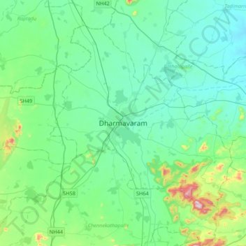
Name: Dharmavaram topographic map, elevation, terrain.

Location: Dharmavaram, Sri Sathya Sai, Andhra Pradesh, 515671, India (14.25384 77.56084 14.57384 77.88084)

Average elevation: 400 m

Minimum elevation: 302 m

Maximum elevation: 865 m

Other topographic maps

Click on a map to view its topography, its elevation and its terrain.

Dharmavaram

India > Andhra Pradesh > Dharmavaram

Average elevation: 388 m

Gear up for your next adventure:

🧴Outdoor Sunscreen - High SPF protection for high-altitude UV exposure
🧢Hiking Hat - Sun-protective and breathable hats for long treks
🛌Insulated Sleeping Pad - Critical thermal barrier between you and the cold ground
🧰Multitool Knife - Compact and versatile tool for outdoor use
Family Camping Tent - Spacious tent suitable for family camping trips

As an Amazon Associate, this site earns from qualifying purchases at no extra cost to you.