Geolocate

Braunston topographic map

Click on the map to display elevation.

About this map

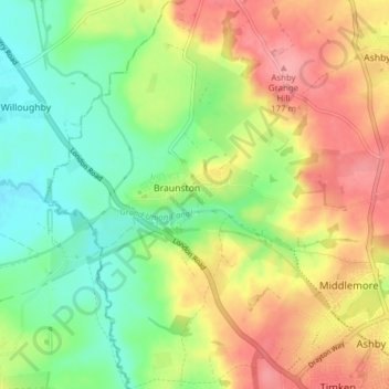
Name: Braunston topographic map, elevation, terrain.

Location: Braunston, West Northamptonshire, England, United Kingdom (52.26750 -1.23379 52.31471 -1.17373)

Average elevation: 128 m

Minimum elevation: 84 m

Maximum elevation: 180 m

Gear up for your next adventure:

🧢Beanie Hat - Keep your head warm in cold weather
🧶550 Survival Paracord - Versatile utility cord for emergency repairs and rigging
🥾Waterproof Hiking Boots - Boots keeping your feet dry in wet conditions
🧦Merino Wool Socks - Moisture-wicking comfort for long-distance hiking
🧴Bear Spray Holster - Quick-access carry for essential Canadian wilderness safety

As an Amazon Associate, this site earns from qualifying purchases at no extra cost to you.