
Marquette topographic map
Click on the map to display elevation.
About this map
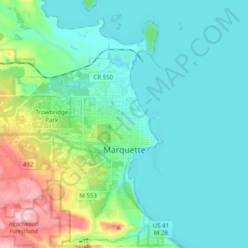
Name: Marquette topographic map, elevation, terrain.
Location: Marquette, Marquette County, Michigan, United States (46.50597 -87.45905 46.59571 -87.36372)
Average elevation: 215 m
Minimum elevation: 172 m
Maximum elevation: 377 m
Other topographic maps
Click on a map to view its topography, its elevation and its terrain.
Van Riper State Park
United States > Michigan > Marquette County > Michigamme Township
Average elevation: 489 m
Skinnies Lake
United States > Michigan > Marquette County > Humboldt Township
Average elevation: 453 m
Horseshoe Lake
United States > Michigan > Marquette County > Republic Township
Average elevation: 503 m