Geolocate

Montecristo topographic map

Click on the map to display elevation.

About this map

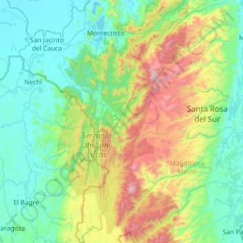
Name: Montecristo topographic map, elevation, terrain.

Location: Montecristo, Mojana, Bolívar, RAP Caribe, Colombia (7.43175 -74.69581 8.43013 -74.25547)

Average elevation: 457 m

Minimum elevation: 17 m

Maximum elevation: 2,186 m

Gear up for your next adventure:

🧦Outdoor Socks - Durable socks designed for hiking and outdoor sports
🔋Solar Power Bank - Keep your GPS and devices charged during long outdoor trips
Lightweight Camping Tent - Portable shelter optimized for Canadian backcountry camping
🎒Hiking Backpack - Lightweight and ergonomic backpacks for day hikes or multi-day treks
🧢Hiking Hat - Sun-protective and breathable hats for long treks

As an Amazon Associate, this site earns from qualifying purchases at no extra cost to you.