
Thank you for supporting this site ❤️
Make a donation
Make a donation
Gear up for your next adventure:
As an Amazon Associate, this site earns from qualifying purchases at no extra cost to you.
Mazarrón topographic map
Click on the map to display elevation.
Thank you for supporting this site ❤️
Make a donation
Make a donation
Gear up for your next adventure:
As an Amazon Associate, this site earns from qualifying purchases at no extra cost to you.
About this map
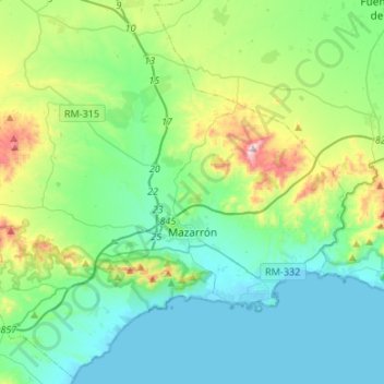
Name: Mazarrón topographic map, elevation, terrain.
Location: Mazarrón, Bajo Guadalentín, Region of Murcia, Spain (37.51728 -1.47576 37.72402 -1.20824)
Average elevation: 151 m
Minimum elevation: -1 m
Maximum elevation: 679 m
Thank you for supporting this site ❤️
Make a donation
Make a donation
Gear up for your next adventure:
As an Amazon Associate, this site earns from qualifying purchases at no extra cost to you.
Other topographic maps
Click on a map to view its topography, its elevation and its terrain.
Alhama de Murcia
Spain > Region of Murcia > Bajo Guadalentín > Alhama de Murcia > Alhama de Murcia
Average elevation: 271 m