
Thank you for supporting this site ❤️
Make a donation
Make a donation
Gear up for your next adventure:
As an Amazon Associate, this site earns from qualifying purchases at no extra cost to you.
Dronero topographic map
Click on the map to display elevation.
Thank you for supporting this site ❤️
Make a donation
Make a donation
Gear up for your next adventure:
As an Amazon Associate, this site earns from qualifying purchases at no extra cost to you.
About this map
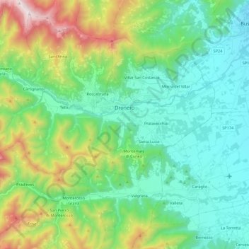
Name: Dronero topographic map, elevation, terrain.
Location: Dronero, Cuneo, Piedmont, Italy (44.42454 7.22922 44.48614 7.44553)
Average elevation: 862 m
Minimum elevation: 486 m
Maximum elevation: 1,939 m
Thank you for supporting this site ❤️
Make a donation
Make a donation
Gear up for your next adventure:
As an Amazon Associate, this site earns from qualifying purchases at no extra cost to you.
Other topographic maps
Click on a map to view its topography, its elevation and its terrain.
F.ne Scaglione
Italy > Piedmont > Cuneo > Santo Stefano Belbo > F.ne Scaglione
Average elevation: 330 m