Geolocate

Lockport topographic map

Click on the map to display elevation.

About this map

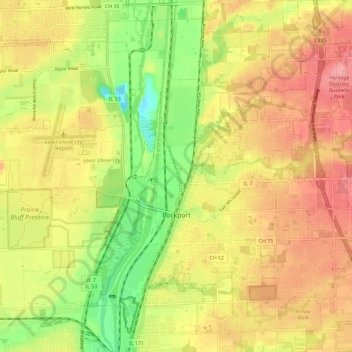
Name: Lockport topographic map, elevation, terrain.

Location: Lockport, Will County, Illinois, 60441, United States (41.55610 -88.07589 41.64158 -87.96348)

Average elevation: 198 m

Minimum elevation: 143 m

Maximum elevation: 242 m

Other topographic maps

Click on a map to view its topography, its elevation and its terrain.

Drummond

United States > Illinois > Will County

Average elevation: 167 m

Puddle Pond

United States > Illinois > Will County > Plainfield

Average elevation: 187 m

Arbury Hills

United States > Illinois > Will County

Average elevation: 216 m

Gear up for your next adventure:

📷Outdoor Action Camera - Capture high-elevation views and rugged adventures
🥾All-Terrain Hiking Boots - Versatile boots for varied hiking conditions
🔦LED Headtorch - Bright and durable light for night activities
Camping Groundsheet - Protect your tent from moisture and dirt
🧦Thermal Socks - Warm socks for winter hiking or camping

As an Amazon Associate, this site earns from qualifying purchases at no extra cost to you.