Geolocate

Tauranga topographic map

Click on the map to display elevation.

About this map

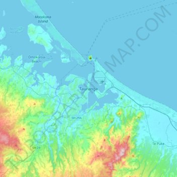
Name: Tauranga topographic map, elevation, terrain.

Location: Tauranga, Tauranga City, Bay of Plenty, 3110, New Zealand (-37.84590 176.00751 -37.52590 176.32751)

Average elevation: 66 m

Minimum elevation: -1 m

Maximum elevation: 548 m

Other topographic maps

Click on a map to view its topography, its elevation and its terrain.

Tauranga

New Zealand > Bay of Plenty > Tauranga City

Average elevation: 63 m

Bayfair

New Zealand > Bay of Plenty > Tauranga City

Average elevation: 8 m

Welcome Bay

New Zealand > Bay of Plenty > Tauranga City

Average elevation: 49 m

Gear up for your next adventure:

❄️Traction Ice Cleats - Slip-on spikes for icy trails and winter hiking
💧Hydration Bladder - Hands-free hydration solution for long treks
🥾Hiking Shorts - Breathable shorts suitable for summer hikes
💡LED Headlamp - Hands-free illumination for night hiking and camping
🧥Packable Rain Jacket - Breathable waterproof layer for unpredictable weather

As an Amazon Associate, this site earns from qualifying purchases at no extra cost to you.