
Vysoké Tatry topographic map
Interactive map
Click on the map to display elevation.
About this map
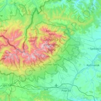
Name: Vysoké Tatry topographic map, elevation, terrain.
Location: Vysoké Tatry, District of Poprad, Region of Prešov, Slovakia (49.08034 19.88393 49.28609 20.38501)
Average elevation: 994 m
Minimum elevation: 569 m
Maximum elevation: 2,601 m
The town of Vysoké Tatry is special in many aspects. It is not a true town, but a conglomerate of separate and different settlements (originally separate villages), whose only common feature is that they are the main tourist resorts in the Slovak High Tatras, while being connected through a common railway network (the Tatra Railway). After the country's capital, the town is Slovakia's major tourist destination. It has around 4,000 inhabitants, excluding tourists. It is located at an elevation of 1,010 m (3,310 ft) above sea level. Covering 360.22 square kilometres (139.1 square miles), it is Slovakia's second-largest urban area, after the country's capital, and was the largest until 2007, when the village of Štrbské Pleso became a part of Štrba after Štrba's municipal government's successful claim on the Supreme Court.
Other topographic maps
Click on a map to view its topography, its elevation and its terrain.
Ždiar
Slovakia > Region of Prešov > District of Poprad
Ždiar, District of Poprad, Region of Prešov, 059 55, Slovakia
Average elevation: 1,105 m
Tatra Mountains
Slovakia > Region of Prešov > District of Poprad
Tatra Mountains, District of Poprad, Region of Prešov, Eastern Slovakia, Slovakia
Average elevation: 922 m
Poprad
Slovakia > Region of Prešov > District of Poprad
Poprad, District of Poprad, Region of Prešov, Slovakia
Average elevation: 709 m
Kriváň
Slovakia > Region of Prešov > District of Poprad > Vysoké Tatry
Kriváň, Vysoké Tatry, District of Poprad, Region of Prešov, Eastern Slovakia, Slovakia
Average elevation: 1,913 m
Gerlachovský štít
Slovakia > Region of Prešov > District of Poprad > Vysoké Tatry
Gerlachovský štít, Vysoké Tatry, District of Poprad, Region of Prešov, Eastern Slovakia, 059 84, Slovakia
Average elevation: 2,103 m