
Make a donation
Gear up for your next adventure:
As an Amazon Associate, this site earns from qualifying purchases at no extra cost to you.
Columbia topographic map
Click on the map to display elevation.
Make a donation
Gear up for your next adventure:
As an Amazon Associate, this site earns from qualifying purchases at no extra cost to you.
Columbia
The city has capitalized on this location, which includes three rivers, by identifying as "The Columbia Riverbanks Region". Columbia is located roughly halfway between the Atlantic Ocean and the Blue Ridge Mountains, at an elevation around 292 ft (89 m).
Make a donation
Gear up for your next adventure:
As an Amazon Associate, this site earns from qualifying purchases at no extra cost to you.
About this map
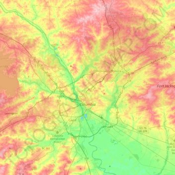
Name: Columbia topographic map, elevation, terrain.
Location: Columbia, Richland County, South Carolina, United States (33.94325 -81.17098 34.13160 -80.70382)
Average elevation: 89 m
Minimum elevation: 12 m
Maximum elevation: 175 m
Make a donation
Gear up for your next adventure:
As an Amazon Associate, this site earns from qualifying purchases at no extra cost to you.
Other topographic maps
Click on a map to view its topography, its elevation and its terrain.
Forest I At Harbison
United States > South Carolina > Richland County > Columbia
Average elevation: 87 m
Make a donation
Gear up for your next adventure:
As an Amazon Associate, this site earns from qualifying purchases at no extra cost to you.
Harbison State Forest
United States > South Carolina > Richland County > Columbia
Average elevation: 79 m
Make a donation
Gear up for your next adventure:
As an Amazon Associate, this site earns from qualifying purchases at no extra cost to you.
Sesquicentennial State Park
United States > South Carolina > Richland County
This park offers three picnic shelters, four picnic pads, and 84 campsites that vary in amenities & sizes. The park provides rental fishing boats, paddle boats, standup paddleboards, kayaks, canoes, fishing access to the 30-acre (12 ha) park lake, and four trails providing over 12 miles (19 km) of recreational…
Average elevation: 97 m
Forest I At Harbison
United States > South Carolina > Richland County > Columbia
Average elevation: 87 m
Riverbanks
United States > South Carolina > Richland County > Columbia > Riverbanks
Average elevation: 69 m
Make a donation
Gear up for your next adventure:
As an Amazon Associate, this site earns from qualifying purchases at no extra cost to you.