Geolocate

Canca topographic map

Click on the map to display elevation.

About this map

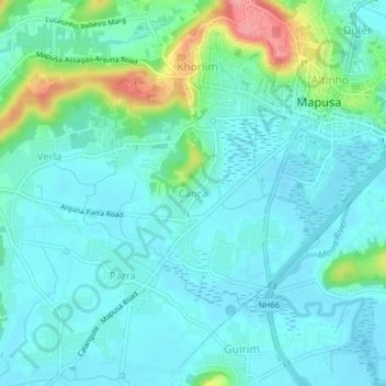
Name: Canca topographic map, elevation, terrain.

Location: Canca, Bardez, North Goa, Goa, 403510, India (15.56318 73.77843 15.60318 73.81843)

Average elevation: 21 m

Minimum elevation: 0 m

Maximum elevation: 102 m

Other topographic maps

Click on a map to view its topography, its elevation and its terrain.

Anjuna

India > Goa > Bardez > Anjuna

Average elevation: 14 m

Pilerne Lake

India > Goa > Bardez > Sangolda

Average elevation: 39 m

Corjuem Fort

India > Goa > Bardez > Corjuem

Average elevation: 13 m

Aguada Fort

India > Goa > Bardez > Sinquerim

Average elevation: 8 m

Anjuna

India > Goa > Bardez

Average elevation: 13 m

Anjuna Beach

India > Goa > Bardez > Anjuna

Average elevation: 10 m

Chapora Fort

India > Goa > Bardez > Chapora

Average elevation: 8 m

Gear up for your next adventure:

🪜Heavy Duty Carabiners - Multi-use clips for securing gear to your backpack
🧴Sunscreen SPF - Broad-spectrum sunscreen for outdoor activities
🧥Waterproof Pants - Keep dry during rainy hiking conditions
🥾Durable Hiking Shoes - Long-lasting shoes for frequent hiking
🥾Trekking Boots - Durable boots for long-distance trekking

As an Amazon Associate, this site earns from qualifying purchases at no extra cost to you.