Geolocate

Schnaittenbach topographic map

Click on the map to display elevation.

About this map
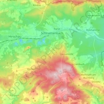
Name: Schnaittenbach topographic map, elevation, terrain.

Location: Schnaittenbach, Landkreis Amberg-Sulzbach, Bavaria, 92253, Germany (49.48064 11.97599 49.57899 12.12228)

Average elevation: 480 m

Minimum elevation: 352 m

Maximum elevation: 676 m

Other topographic maps

Click on a map to view its topography, its elevation and its terrain.
Augsberg

Germany > Bavaria > Landkreis Amberg-Sulzbach > Birgland

Average elevation: 546 m

Vilshofen

Germany > Bavaria > Landkreis Amberg-Sulzbach

Average elevation: 416 m

Hohenzant

Germany > Bavaria > Landkreis Amberg-Sulzbach > Vilseck

Average elevation: 460 m

Kürmreuth

Germany > Bavaria > Landkreis Amberg-Sulzbach

Average elevation: 466 m

Pursruck

Germany > Bavaria > Landkreis Amberg-Sulzbach

Average elevation: 496 m

Vilshofen

Germany > Bavaria > Landkreis Amberg-Sulzbach

Average elevation: 416 m

Gear up for your next adventure:

💧Reusable Water Bottle - Durable water bottles for hydration on trails
⛺Family Camping Tent - Spacious tent suitable for family camping trips
🧰Survival Kit - Essential gear for emergencies in the wilderness
🚑Survival Whistle - Signal for help across long distances in mountains
🥾Lightweight Hiking Boots - Boots for comfort and mobility on long hikes

As an Amazon Associate, this site earns from qualifying purchases at no extra cost to you.