
Thank you for supporting this site ❤️
Make a donation
Make a donation
Gear up for your next adventure:
As an Amazon Associate, this site earns from qualifying purchases at no extra cost to you.
Mudhol topographic map
Click on the map to display elevation.
Thank you for supporting this site ❤️
Make a donation
Make a donation
Gear up for your next adventure:
As an Amazon Associate, this site earns from qualifying purchases at no extra cost to you.
About this map
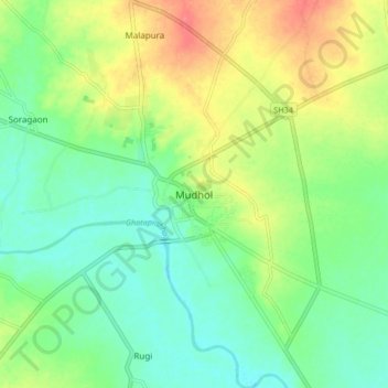
Name: Mudhol topographic map, elevation, terrain.
Location: Mudhol, Mudhola taluku, Bagalkote, Karnataka, 587313, India (16.29386 75.24708 16.37386 75.32708)
Average elevation: 547 m
Minimum elevation: 525 m
Maximum elevation: 582 m
Thank you for supporting this site ❤️
Make a donation
Make a donation
Gear up for your next adventure:
As an Amazon Associate, this site earns from qualifying purchases at no extra cost to you.