Geolocate

Munjungan topographic map

Click on the map to display elevation.

About this map

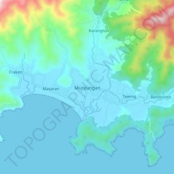
Name: Munjungan topographic map, elevation, terrain.

Location: Munjungan, Trenggalek, East Java, Java, Indonesia (-8.34288 111.53633 -8.26288 111.61633)

Average elevation: 125 m

Minimum elevation: 0 m

Maximum elevation: 840 m

Gear up for your next adventure:

💡Compact LED Flashlight - Powerful and portable flashlight for outdoor use
🧥Ultralight Puffy Jacket - Maximum warmth that packs down to the size of an orange
🚲Bike Repair Kit - Essential tools for on-trail mechanical issues
🥾Approach Boots - Comfortable boots for hiking and climbing approaches
🥾Waterproof Hiking Boots - Essential footwear for rugged terrain and wet Canadian trails

As an Amazon Associate, this site earns from qualifying purchases at no extra cost to you.